AI-Powered Roof Detection & 3D Modeling
Transform satellite imagery, drone photos, and map provider data into precise roof segmentation, measurements, and downloadable 3D CAD models — powered by deep learning.
Seamlessly integrates with leading map & imagery providers
Features
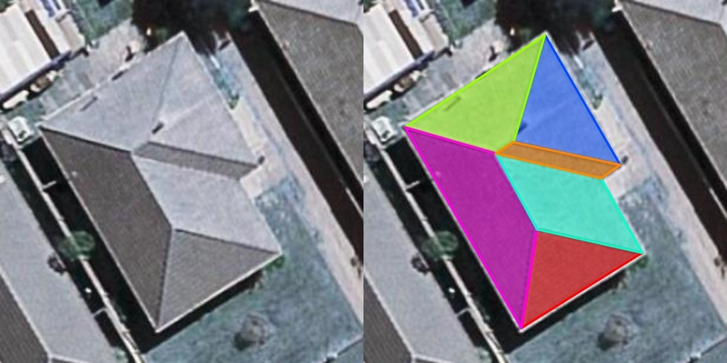
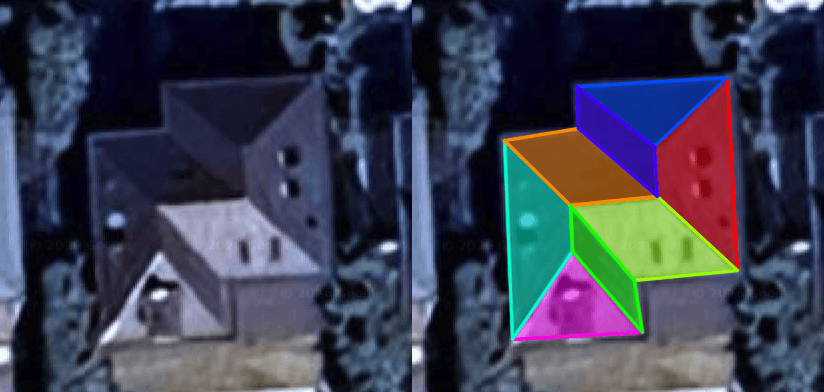
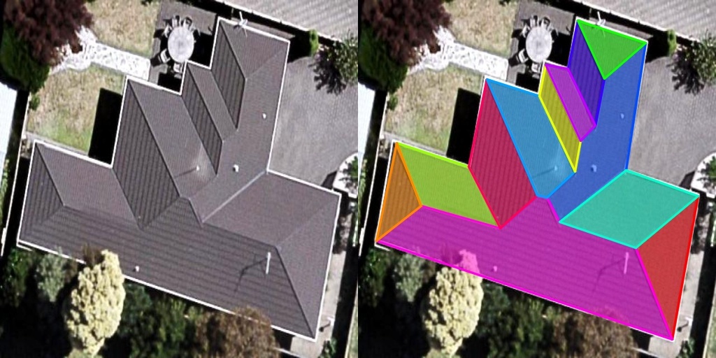
AI Roof Face Detection
Upload any aerial or satellite image and our deep learning model identifies every roof face — ridges, hips, valleys, and flat sections with pixel-level precision.
Multi-Face Segmentation
Identifies and separates each individual roof plane, including complex multi-level geometries.
Edge & Ridge Detection
Precisely locates ridgelines, hip lines, valleys, and eaves for complete structural mapping.
Confidence Scoring
Each detected face includes a confidence score so you know exactly how reliable the results are.

3D Model Generation
When DSM or LIDAR data is available for your target location, RoofBuilder reconstructs a full 3D roof model exportable in industry-standard CAD formats.
DSM & LIDAR Integration
Combines elevation data with AI detection to create geometrically accurate 3D meshes.
CAD Export
Download models in DXF, OBJ, or STL formats for seamless integration with your design workflow.
Automated Measurements
Automatically extract roof area, pitch angles, ridge lengths, and elevation data from the 3D model.
Interactive 3D Viewer
Visualize your roof models in real-time with our BabylonJS-powered 3D viewer. Upload an image and see the 3D reconstruction instantly — no software installation needed.
Browser-Based Rendering
Powered by BabylonJS for smooth, interactive 3D visualization directly in your browser.
Annotation Tools
Add notes, mark areas of interest, and highlight specific roof sections for team collaboration.
Share & Embed
Generate shareable links or embed the 3D viewer directly into your own applications and reports.
How It Works
From image to 3D model in four simple steps.
Upload Image
Upload satellite, drone, or map provider imagery. Connect Google Maps, Azure Maps, or Vexcel APIs for automated image fetching.
AI Detection
Our deep learning algorithms analyze the image, detecting every roof face, edge, and structural element in seconds.
Review Results
Explore detected roof segments, measurements, and confidence scores through our interactive dashboard and 3D viewer.
Export & Integrate
Download 3D models in CAD formats, view in our BabylonJS viewer, or access results programmatically via our REST API.
Simple, Transparent Pricing
Choose the plan that fits your needs. Scale as you grow.
Starter
$79/mo
FEATURES
Core features included
- 500 images per month
- Roof face detection
- 2D measurements & area calculation
- REST API access
- JSON & GeoJSON output
- Email support
Professional
$249/mo
FEATURES
Everything in Starter, plus...
- 2,500 images per month
- Everything in Starter
- 3D model generation (DSM/LIDAR)
- CAD export (DXF, OBJ, STL)
- BabylonJS 3D viewer access
- Priority support & webhooks
- Batch processing
Enterprise
Custom
FEATURES
Everything in Professional, plus...
- Unlimited image processing
- Everything in Professional
- On-premise deployment option
- Custom model training
- SLA guarantee (99.9% uptime)
- Dedicated account manager
- Custom API integrations
Trusted by Industry Leaders
See how teams across solar, construction, and insurance use RoofBuilder.

Marcus Werner
CTO at SolarPlan GmbH
"RoofBuilder has cut our roof assessment time by 80%. What used to take hours of manual measurement now happens in seconds with remarkable accuracy."

Sarah Chen
VP Engineering at InsureVision
"The 3D modeling capability is a game-changer for our damage assessment workflow. We integrated the API in days and our adjusters love the interactive viewer."

David Petrov
Lead Architect at UrbanDesign Co.
"The precision of the roof face detection is impressive. Being able to export directly to CAD has streamlined our entire building survey process."
1M+
Roofs analyzed and processed through our AI pipeline, delivering accurate segmentation results worldwide.
99.2%
Average detection accuracy across standard aerial and satellite imagery, validated on industry benchmarks.
150+
Countries covered with satellite and map provider imagery support, enabling global roof analysis at scale.
Start Detecting Roofs in Minutes
Sign up for free and experience the power of AI-driven roof analysis. No credit card required to get started.